Experiencing America > Trip Year 2022 > Mountains, the Carolinas, and the Colonel > Day 3
Day THREE...
Wednesday, March 30th, 2022
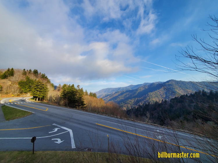
Day three in East Tennessee was devised as a plan for the group to split. Some stayed in the Pigeon Forge-Gatlinburg Area, and a few others took off for a day road trip around the Great Smokey Mountains. To give more time to see more we started off just about sunrise and headed south into the Great Smokey Mountain National Park to avoid the tourist traffic of the area. The plan was to take U.S. 441 straight up the mountains and down on the North Carolina side.

Looking out at the Chimney Top Overlook.
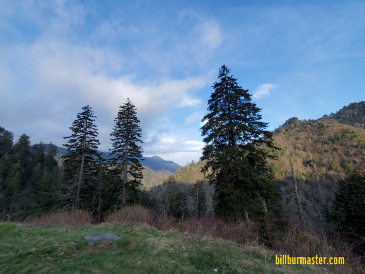
Looking out at the Ben Morton Overlook.
Looking west at Newfoundland Gap.

Looking west at Newfoundland Gap.

Looking south at Newfoundland Gap.
Now to State 6!!...North Carolina...

The marker at Newfoundland Gap for the Tennessee/North Carolina State Line.
The state line on U.S. 441 between North Carolina and Tennessee is not clearly marked. From here it was downward through the North Carolina side of the Great Smokey Mountains. This was marked with curves, twists, turns, trees, and waterfalls. As we got closer to the bottom we started to run along the Oconaluftee River. This was a very scenic and pretty sights.

Looking along the Oconaluftee River.
As we descended the mountain on U.S. 441 there were many National Park Service Fire vehicles heading up the mountain. This was a pre-curser to the later events of the day. It is a good thing the plan was to head over to Interstate 26 and Interstate 40 to go north across the mountain, and not back up U.S. 441.

A variable message board on NB U.S. 441.

A variable message board on NB U.S. 441.
As we left the Great Smokey Mountains it was the plan to keep heading south along U.S. 441. This first took us through Cherokee, North Carolina. Here there were a few arts shops, and museums. As we headed south in Western North Carolina, we tried to stop at the House Cat Museum, but that was closed.

A totem pole in Cherokee.
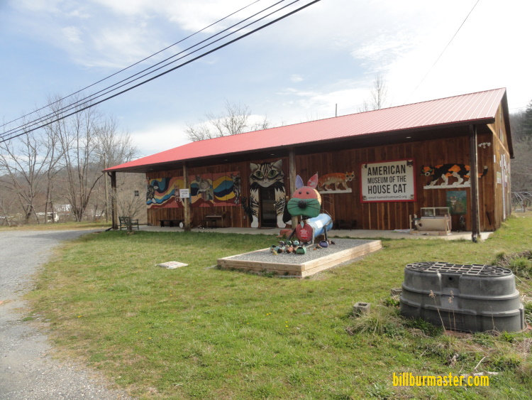
The cat museum.
Now to State #7!!...Georgia...

The Georgia Welcome Sign on SB U.S. 23/441.
The first stop in Georgia was up to Sky Valley. Along the road going up to the overlook you get a view of a Estatoah Fall that is not accessible to the public, but is viewable when you head east along Georgia 246. Between U.S. 23/441 and Sky Valley, Georgia 246 crosses in and out of North Carolina numerous times as it goes up the mountain. After a stop at Sky Valley, it was time to head south to Clayton, then start heading east.

Looking at Estatoah Falls.

Looking south from Sky Valley.
Now to State #8!!...South Carolina...

EB U.S. 76 at the South Carolina Welcome Sign, at the Georgia/South Carolina State Line.
This is the first time we have ever ventured into South Carolina. It has made for a new land for EA to explore. At the Georgia/South Carolina State Line there was a roadside park along the South Carolina side of the Chattooga River. The river crossing on U.S. 76 had a sidewalk across the river at the state line.

Looking toward Georgia from the South Carolina side of the Chattooga River, along U.S. 76.

Looking south along the Chattooga River from U.S. 76.

Looking north along the Chattooga River.
The path on the map was to take U.S. 76 to U.S. 123 towards Greenville. This took us through Seneca, and Clemson among other towns. It was a relaxing drive that slowly turned from back woods two lane roads to multi-lane expressway and city driving. All of which was calming, and enjoyable. Once to Greenville, we ended up on Shoeless Joe Jackson Parkway. This sparked and idea. Where did the Great Chicago White Sox player end up for the afterlife. A quick Google search found the final resting place for Shoeless Joe, and we stopped to pay out respects. From Greenville, we headed towards Spartanburg to get to Interstate 26, to start heading north.

A mural in Downtown Seneca, SC.

The grave marker of Shoeless Joe Jackson.
Back to State #6!!...North Carolina...

The North Carolina Welcome Sign on WB I-26 at the North Carolina/South Carolina State Line.
Going through North Carolina on Interstate 26, it was more of a pass through to get back up and over to Pigeon Forge, Tennessee. This was because we were notified of wildfires that had broken out east of Pigeon Forge earlier in the day. Since it was already established we couldn't turn back and use U.S. 441 to cross back over, Interstate 26 and Interstate 40, were the faster path back across the mountains to get to U.S. 411 and head back to town. As we headed through North Carolina...we found Batman's secret.

A sign for the Batcave off of WB I-26.
Back to State #5!!...Tennessee...

The Tennessee Welcome Sign on WB I-40 at the North Carolina/Tennessee State Line.
With the wildfires that broke out earlier in the day east of Pigeon Forge, actually a lot closer to our hotel than earlier in the day; the decision was made to get a different room up the road. The evacuation area set by the Sevier County officials was just a little to close for our comfort. As we moved out of Pigeon Forge and up to Interstate 40, we were met with reinforcements of multiple Tennessee fire departments that have been called in from further out in the state to help battle this wild fire. Shortly after two in the morning more arrived.
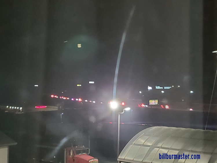
A line of fire trucks coming in along I-40.
Day FOUR