Roads of the Mid-South & West > Highways of the Commonwealth of Kentucky > Interstate 75, Kentucky
 | Interstate 75 |  |
Interstate 75 is a north-south highway in Central Tennessee. This is the main link between Covington, KY-Cincinnati, OH, Lexington, and Richmond. In the southern portion of the state, I-75 crosses through the Future Interstate 66 corridor, near London.
While in Kentucky, I-75 is multi-plexed.
I-75 is multi-plexed with...
...U.S. Rt. 25, near Spears.
...U.S. Rt. 421, near Spears.
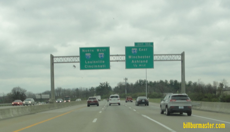
...Interstate 64, near Lexington.

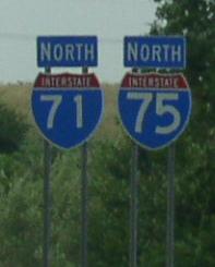
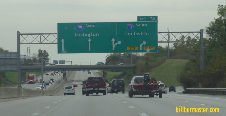
...Interstate 71, from near Walton to the Ohio/Kentucky State Line.


In Kentucky, Interstate 75 crosses the following interstates.
Interstate 64, at Lexington.

EB I-64/SB I-75 two miles from east I-64. (October, 2017)

EB I-64/SB I-75 near east I-64. (October, 2017)

EB I-64/SB I-75 at east I-64. (October, 2017)

NB I-75 over seven mile from east I-64. (March, 2022)

NB I-75 one mile from east I-64. (March, 2022)

NB I-75 a half mile from east I-64. (March, 2022)

NB I-75 near east I-64. (March, 2022)

NB I-75 at east I-64. (March, 2022)
Interstate 64, at Lexington.

SB I-75 under two miles from west I-64. (October, 2017)

SB I-75 near west I-64. (October, 2017)

SB I-75 at west I-64. (October, 2017)

WB I-64/NB I-75 over one mile from west I-64. (March, 2022)

WB I-64/NB I-75 a half mile from west I-64. (March, 2022)

WB I-64/NB I-75 at west I-64. (March, 2022)
Interstate 71, near Walton.

NB I-75 at the one mile mark for the interchage with I-71.

Overhead signs for I-71 on NB I-75.

BGS for SB I-71 on NB I-75.

NB I-75 at I-71 near Walton.

SB I-71/75 one mile from south I-71. (October, 2017)

SB I-71/75 near south I-71. (October, 2017)

SB I-71/75 at south I-71. (October, 2017)

SB I-71/75 one mile from south I-71. (March, 2022)

SB I-71/75 near south I-71. (March, 2022)

SB I-71/75 at south I-71. (March, 2022)
Interstate 275, at Crestview Hills.

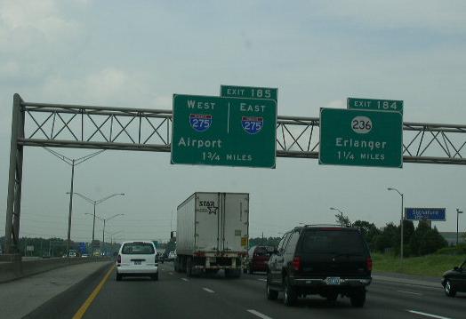
BGS on NB I-71/75 for I-275.

BGS for I-275 on NB I-71/75. Note how "TO I-471" is displayed.

NB I-71/75 near I-275.

NB I-71/75 at I-275.

NB I-71/75 at the stack interchange with I-275.

NB I-71/75 under two miles from I-275. (July, 2019)

NB I-71/75 under one mile from I-275. (July, 2019)

NB I-71/75 near I-275. (July, 2019)

NB I-71/75 at I-275. (July, 2019)
Branches of I-75 in Kentucky.


SB I-75 north of the Tennessee State Line.

SB I-75 near Saxton.

SB I-75 south of KY St Rt 628.

SB I-75 near Pleasant View.

SB I-75 south of KY St Rt 92.

SB I-75 south of KY St Rt 92.

SB I-75 at KY St Rt 92.

A guide marker on WB KY St Rt 296.

SB I-75 north of U.S. Rt. 25W north of Williamsburg.

SB I-75 near Goldbug.

SB I-75 at U.S. Rt. 25W.

SB I-75 at U.S. Rt. 25W.

A guide marker on SB U.S. Rt. 25W.

NB I-75 north of U.S. Rt. 25W-Corbin.

NB I-75 at the Laurel/Whitley County Line.

SB I-75 south of the Laurel/Whitley County Line.

SB I-75 at the Laurel/Whitley County Line.

SB I-75 at the Laurel/Whitley County Line.

SB I-75 south of U.S. Rt. 25/25E.

A guide marker on NB U.S. Rt. 25E.

A guide marker on WB KY St Rt 312.

A guide marker on EB KY St Rt 312.

SB I-75 at U.S. Rt. 25/25E.

SB I-75 north of U.S. Rt. 25/25E.

SB I-75 near Corbin.

SB I-75 south of KY St Rt 192.

SB I-75 south of KY St Rt 192.

NB I-75 at KY St Rt 192.

A set of guide markers on SB KY St Rt 363.

A set of guide markers on WB KY St Rt 192.

A BGS on SB I-75.

SB I-75 south of KY St Rt 80.

A BGS on EB KY St Rt 80.

SB I-75 south of KY St Rt 909.

SB I-75 at KY St Rt 909.

SB I-75 at KY St Rt 909.

SB I-75 at the Laurel/Rockcastle County Line.

SB I-75 near the Rockcastle River.

SB I-75 near Sandy Hill.

SB I-75 near Sandy Hill.

SB I-75 south of U.S. Rt. 25, south of Mount Vernon.

SB I-75 near U.S. Rt. 25.

A junction marker on SB U.S. Rt. 25.

SB I-75 near Conway.

SB I-75 near the Madison/Rockcastle County Line.

SB I-75 south of KY St Rt 21.

SB I-75 at KY St Rt 21.

A set of guide markers on NB KY St Rt 595.

A set of guide markers on NB KY St Rt 595.

SB I-75 south of KY St Rt 876.

A set of guide markers on EB KY St Rt 876.

SB I-75 north of KY St Rt 876.

SB I-75 south of KY St Rt 627.

NB I-75 at the Madison/Fayette County Line.

SB I-75 south of KY St Rt 418.

SB I-75 north of KY St Rt 418.

A BGS on SB I-75.

EB I-64/SB I-75 north of U.S. Rt. 27/68.

EB I-64/SB I-75 south of KY St Rt 922.

A BGS on EB I-64/SB I-75.

A BGS on EB I-64/SB I-75.

EB I-64/SB I-75 south of U.S. Rt. 25.

A guide marker on SB U.S. Rt. 25/EB KY Sec St Rt 1973.

A guide marker on EB KY Sec St Rt 1973.

A junction marker on EB U.S. Rt. 460.

SB I-75 south of U.S. Rt. 62.

SB I-75 south of KY Sec St Rt 3552.

A BGS on SB I-75.

SB I-75 at KY Sec St Rt 3552.

SB I-75 north of KY Sec St Rt 3552.

SB I-75 at KY St Rt 620.

SB I-75 at KY St Rt 620.

SB I-75 north of KY St Rt 620.

SB I-75 near Sadieville.

SB I-75 south of KY St Rt 32.

A SB guide marker.

SB I-75 north of KY St Rt 32.

SB I-75 near Eagle Creek.

SB I-75 at the Scott/Grant County Line. (October, 2017)

SB I-75 at the Scott/Grant County Line. (March, 2022)

SB I-75 north of KY St Rt 330.

SB I-75 south of KY St Rt 36. (October, 2017)

SB I-75 south of KY St Rt 36. (March, 2022)

A junction marker on WB KY St Rt 36.

NB I-75 at KY St Rt 36 near Williamstown.

A guide marker on SB U.S. Rt. 25.

NB I-75 near Dry Ridge.

SB I-75 at KY St Rt 1560.

A guide marker on KY Sec St Rt 3025.

SB I-75 south of KY St Rt 22.

SB I-75 at KY St Rt 22.

A set of guide markers on EB KY St Rt 22.

SB I-75 north of Dry Ridge.

SB I-75 near Sherman.

SB I-75 south of KY St Rt 491. (October, 2022)

SB I-75 south of KY St Rt 491. (March, 2022)

SB I-75 at the Kenton/Grant County Line.

SB I-75 north of KY St Rt 491. (October, 2017)

SB I-75 north of KY St Rt 491. (March, 2022)

NB I-75 near Crittenden.

SB I-75 at the Boone/Kenton County Line.

NB I-75 in southwestern Kenton County.

SB I-75 south of KY Sec St Rt 1416.

SB I-75 north of KY Sec St Rt 1416.

SB I-75 at south I-71.

NB I-71/75, near Union.

SB I-71/75 near M.P. 177.

A BGS on SB I-71/75.

A BGS on SB I-71/75.

SB I-71/75 south of U.S. Rt. 42/127.

SB I-71/75 at U.S. Rt. 42/127.

SB I-71/75 at Mall Road.

Mile marker on NB I-71/75.

A BGS on SB I-71/75.

A guide marker on WB KY St Rt 18.

A guide marker on WB KY St Rt 18.

A guide marker on WB KY St Rt 18.

SB I-71/75 near KY St Rt 18.

A guide marker on EB KY St Rt 842.

A guide marker on EB KY St Rt 842.

A guide marker on WB KY St Rt 842.

A guide marker on KY Sec St Rt 1017.

A guide marker on KY Sec St Rt 1017.

A BGS on EB KY Sec St Rt 1017.

A guide marker on SB KY St Rt 842.

NB I-71/75 at the Boone/Kenton County Line.

SB I-71/75 at the Boone/Kenton County Line.

NB I-71/75 at I-275.

A BGS on SB I-71/75.

NB I-71/75 near the Airport.

A BGS on EB I-275.

A BGS on EB I-275.

A BGS on WB I-275.

A BGS on EB KY St Rt 236.

A guide marker on EB KY St Rt 236.

NB I-71/75 at KY St Rt 371.

A guide marker on KY Sec St Rt 1072.

NB I-71/75 at KY Sec St Rt 1072.

NB I-71/75 at KY Sec St Rt 1072.

SB I-71/75 near KY Sec St Rt 1072.

NB I-71/75 south of MLK in Covington.

SB I-71/75 near Kenney Park in Covington.

SB I-71/75 at Pike Street in Covington.

BGS on NB I-71/75 near the Ohio River.

NB I-71/75 at 9th Street in Covington.

NB I-71/75 near the Ohio River.

A close up of the BGS from the picture above.

NB I-71/75 north of 9th Street in Covington.

SB I-71/75 south of 5th Street in Covington.

A BGS on WB KY St Rt 8.

A set of guide markers on WB U.S. Rt. 42/SB U.S. Rt. 25/127.

A set of guide markers on WB U.S. Rt. 42/SB U.S. Rt. 25/127.

SB I-71/75 at the Kentucky Welcome Sign. (October, 2017)

SB I-71/75 at the Kentucky Welcome Sign. (March, 2022)

NB I-71/75 south the Ohio River.

NB I-71/75 south of the Ohio River.

The last BGS in Kentucky on NB I-71/75.

NB I-71/75 on the southern bank of the Ohio River.

NB I-71/75 crossing the Ohio River into Downtown Cincinnati, OH.

NB I-71/75 crossing the Ohio River.

NB I-71/75 crossing the Ohio River. SB I-71/75 is on the upper level.

SB I-71/75 crossing the Ohio River.
29 January 2023