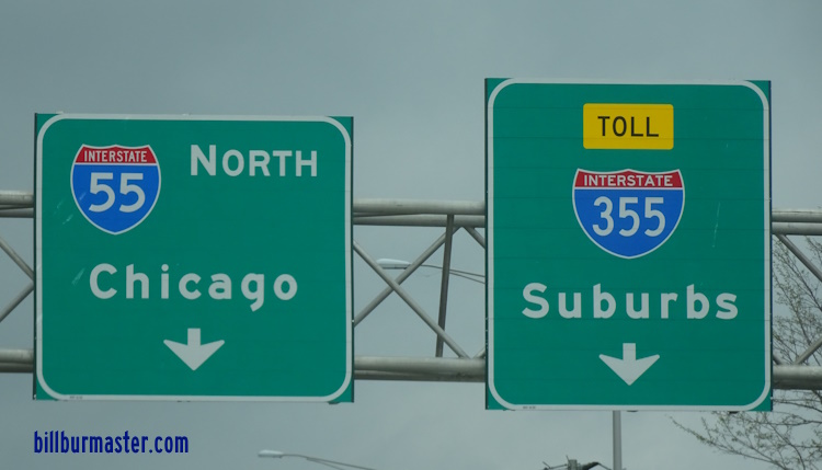
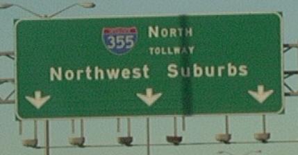
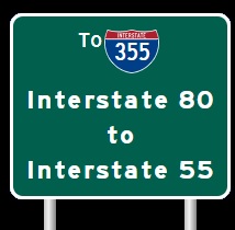
A BGS on NB I-55. A BGS on NB I-55. A BGS on NB I-55. A BGS on SB I-55. A set of guide markers on NB Joliet Road. A set of BGS's on NB Joliet Road. A BGS on NB Joliet Road. The former southern end sign at I-55 prior 2007. Tollway greeting sign on NB I-355 near I-55. Junction sign on EB Boughton Road. Guide signs at I-355 on EB Boughton Road. BGS for the ramp to SB I-355. Note the use of a narrow shield, and the state name is included. A junction marker on WB Boughton Road. SB I-355 at the Du Page/Will County Line. NB I-355 at the Will/Du Page County Line. NB I-355 near 75th Street. NB I-355 at 75th Street. NB I-355 at 75th Street. NB I-355 north of 75th Street. NB I-355 near 63rd Street. NB I-355 at 63rd Street. A junction marker on Hobson Road. A BGS on WB 63rd Street. A guide marker on WB 63rd Street. Sign on NB I-355. A junction marker on EB Maple Ave. A BGS on Maple Ave. in Downers Grove. (Nov., 2007) NB I-355 at U.S. Rt. 34/Ogden Ave. A guide marker on Main Street in Downers Grove. A set of junction markers on EB U.S. Rt. 34. A set of guide markers on EB U.S. Rt. 34. A BGS guide sign on EB U.S. Rt. 34. A set of guide markers on EB U.S. Rt. 34. A junction marker on WB U.S. Rt. 34. A junction marker on WB U.S. Rt. 34. A guide marker on WB U.S. Rt. 34. A set of BGS's on a ramp from U.S. Rt. 34. SB I-355 near Ogden Ave. NB I-355 north of U.S. Rt. 34/Ogden Ave. A junction marker on EB U.S. Rt. 34. NB I-355 at the tunnel under I-88. I-355 curves under I-88 in a tunnel. BGS on WB I-88. BGS on EB I-88 for SB I-355. Overhead sign on EB I-88. A BGS on EB I-88/IL St Rt 110. A BGS on EB I-88/IL St Rt 110. NB I-355 at Finley Road. NB I-355 near the ramp from SB I-355 to EB and WB I-88. Overhead sign on NB I-355. A BGS on NB I-355. A BGS on NB I-355. A BGS on NB I-355. A BGS on NB I-355. Sign on IL St Rt 56 at I-355 in Downers Grove. A guide marker on NB Highland Ave. A BGS on NB Highland Ave. Toll plaza on the entrance ramp to SB I-355 from IL St Rt 56. NB I-355 at Butterfield Road (IL St Rt 56). NB I-355 at Butterfield Road (IL St Rt 56). NB I-355 at 22nd Ave. NB guide marker. A junction marker on EB IL St Rt 38. A guide marker on EB IL St Rt 38. A BGS on WB IL St Rt 38. NB I-355 south of St. Charles Road. NB I-355 south of North Ave. NB I-355 at IL St Rt 64/North Ave. A junction marker on WB IL St Rt 64. A set of guide markers on WB IL St Rt 64. A BGS on WB IL St Rt 64. A guide marker on SB IL St Rt 53. A construction warning sign on NB I-355 near the Army Trail Toll Plaza. (Nov. 2005) One of the few guide markers to have the Ike System Marker and a Toll marker on it. BGS on SB I-355. Thank you sign on NB I-355 near Lake Street. SB I-355 at Army Trail Road. A BGS on SB I-355. A BGS on EB Army Trail Road. A BGS on EB Army Trail Road. (November, 20230 BGS for the Army Trail Road Exit. This is the last exit SB before the tollway. SB I-355 north of Army Trail Road. NB I-355 near Lake Street (U.S. Rt. 20). A guide marker on WB U.S. Rt. 20. A guide marker on WB U.S. Rt. 20. A guide sign on WB I-90 (Northwest Tollway). A BGS on WB I-90. A set of guide signs on WB DPCH 26. A BGS on WB IL St Rt 390. A BGS on EB IL St Rt 390. A BGS on EB IL St Rt 390. The northern end of I-355 is not markered, prior to 2012. All traffic enters either east or westbound I-290 at Itasca. The northern end of I-355. The northern end marker. The northern end marker. (September, 2019)