Interstate 74 De Witt/Mc Lean County Line to Tazewell/Woodford County Line
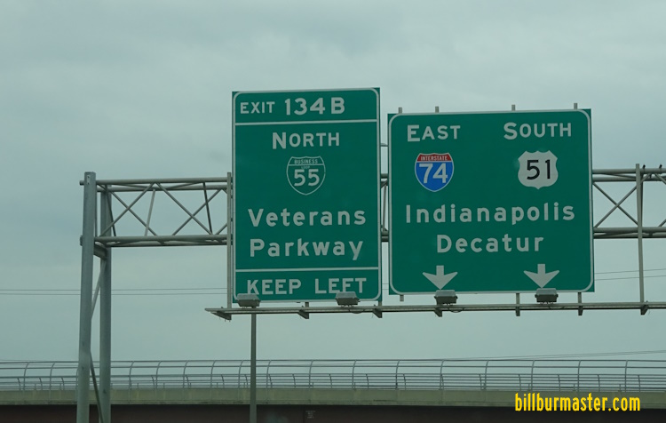
EB I-74 east of U.S. Rt. 136. EB I-74 east of U.S. Rt. 136. WB I-74 at U.S. Rt. 136. WB I-74 near Le Roy. EB I-74 east of Downs. A BGS near Downs. A junction sign on NB U.S. Rt. 51. A BGS on NB U.S. Rt. 51. A BGS on SB BUSN U.S. Rt. 51. Looking west along I-74 at U.S. Rt. 51, on the southside of Bloomington. EB I-74/SB U.S. Rt. 51 at BUSN Loop I-55. A BGS on EB I-74/SB U.S. Rt. 51. A BGS on NB I-55. A BGS on NB I-55. A junction marker on SB BUSN Loop I-55. A BGS on SB BUSN Loop I-55. WB I-74/NB U.S. Rt. 51 as NB I-55 traffic merges in from the left. Looking south at the interchange with I-55/74; BUSN Loop I-55 in Bloomington. Left-to-Right: (2-lanes)WB I-74/NB U.S. Rt. 51; (2-lanes)NB I-55; (2-lanes)EB I-74/SB U.S. Rt. 51; (2-lanes)SB I-55. Photo taken from Fox Creek Road overpass. A BGS on SB I-55/U.S. Rt. 51; EB I-74. A look down NB I-55/WB I-74/NB U.S. Rt. 51 on the westside of Bloomington. WB I-74/NB I-55/NB U.S. Rt. 51 heading north on the westside of Bloomington. NB I-55/U.S. Rt. 51; WB I-74 at U.S. Rt. 150/IL St Rt 9. A BGS on EB U.S. Rt. 150/IL St Rt 9. A junction marker on EB U.S. Rt. 150/IL St Rt 9. A BGS on WB U.S. Rt. 150/IL St Rt 9. A BGS on EB U.S. Rt. 150/IL St Rt 9. A BGS on EB U.S. Rt. 150/IL St Rt 9. NB I-55/U.S. Rt. 51; WB I-74 north of U.S. Rt. 150/IL St Rt 9. A junction marker on WB U.S. Rt. 150/IL St Rt 9. A BGS on SB I-55 on the northeast side of Normal. A BGS on NB BUSN Loop I-55. A guide sign on BUSN. U.S. Rt. 51 in Normal. A BGS on SB I-39/U.S. Rt. 51. (July, 2024) WB I-74 going under I-55 at Normal. WB I-74 west of I-55. A guide sign on WB U.S. Rt. 150. EB I-74 at U.S. Rt. 150 near Normal. WB I-74 west of U.S. Rt. 150. EB I-74 at Carlock. A guide sign in Carlock. WB I-74 west of Carlock. WB I-74 at the Mc Lean/Woodford County Line. EB I-74 at the Mc Lean/Woodford County Line. WB I-74 near Congerville. WB I-74 near Congerville. A guide marker near the WB rest area. EB I-74 near the Mackinaw River. WB I-74 near Goodfield. EB I-74 at the Tazewell/Woodford County Line. EB I-74 at the Tazewell/Woodford County Line.