U.S. Federal Route 45 is a north-south highway in Cook County. This is one of the longest counties that this highways passes through while in Illinois. It is one of the busiest north-south surface highways in this part of the county. U.S. Rt. 45 passes through the following towns in Cook County. Tinley Park
Orland Hills
Orland Park
Palos Park
Willow Springs
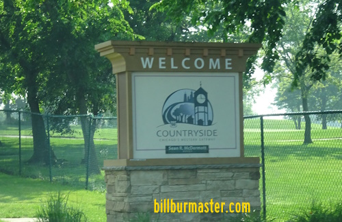
Hodgkins Countryside
Justice
La Grange La Grange Park
Westchester Hillside
Bellwood
Melrose Park
Stone Park
Northlake
Franklin Park
Schiller Park
Chicago
Rosemont
Des Plaines
Mount Prospect
Prospect Heights
Wheeling
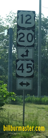
U.S. Rt. 45 is multi-plexed in Cook County. U.S. Rt. 12, from near Hickory Hills to Des Plaines.
U.S. Rt. 20, from near Hickory Hills to Stones Park.
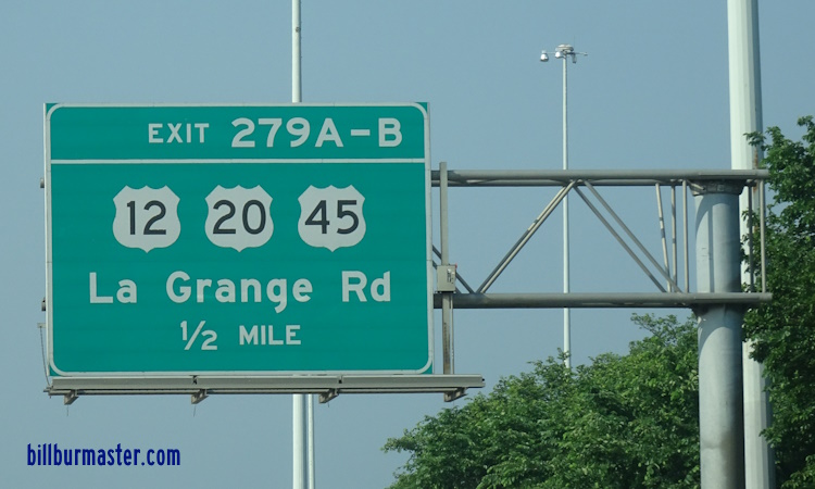
NB U.S. Rt. 45/IL St Rt 21 in Wheeling. A junction marker on EB IL St Rt 68. WB U.S. Rt. 12/NB U.S. Rt. 45 north of Miner Street in Des Plaines. WB U.S. Rt. 12/NB U.S. Rt. 45 at Elmwood in Des Plaines. WB U.S. Rt. 12/NB U.S. Rt. 45 near Oakwood in Des Plaines. WB U.S. Rt. 12/NB U.S. Rt. 45 south of IL St Rt 72. WB U.S. Rt. 12/NB U.S. Rt. 45 north of I-190. A set of BGS's on EB I-190. A BGS on WB I-190. WB U.S. Rt. 12/NB U.S. Rt. 45 at I-190. EB U.S. Rt. 12/SB U.S. Rt. 45 at O'Hare International Airport. A BGS on WB Balmoral. WB U.S. Rt. 12/NB U.S. Rt. 45 at Balmoral. A street sign on WB IL St Rt 19. WB U.S. Rt. 12/NB U.S. Rt. 45 at IL St Rt 19. WB U.S. Rt. 12/NB U.S. Rt. 45 at I-294. A guide marker in Franklin Park. A guide marker in Franklin Park. EB U.S. Rt. 12/SB U.S. Rt. 45 near Wrightwood in Franklin Park. EB U.S. Rt. 12/SB U.S. Rt. 45 near Fullerton in Franklin Park. NB U.S. Rt. 12/45 in Melrose Park. NB U.S. Rt. 12/45 near IL St Rt 64. A junction marker on EB IL St Rt 64. A junction marker on EB IL St Rt 63. A guide marker on EB IL St Rt 64. A guide marker on EB IL St Rt 64. WB U.S. Rt. 12/NB U.S. Rt. 45 north of west U.S. Rt. 20. A junction marker on EB U.S. Rt. 20. A junction marker on EB U.S. Rt. 20. A street sign on a stop light mast in Melrose Park. EB U.S. Rt. 12/20; SB U.S. Rt. 45 south of Lake Street. WB U.S. Rt. 12/20; NB U.S. Rt. 45 at I-290/IL St Rt 110. A BGS on EB I-290. A BGS on EB I-290. A BGS on EB I-290/IL St Rt 110. A BGS on EB I-88/IL St Rt 110. A BGS on EB I-290/IL St Rt 110. A junction marker on EB IL St Rt 38. NB U.S. Rt. 12/45; WB U.S. Rt. 20 north of IL St Rt 38. EB U.S. Rt. 12/20; SB U.S. Rt. 45 south of Cermak. EB U.S. Rt. 12/20; SB U.S. Rt. 45 in La Grange Park. EB U.S. Rt. 12/20; SB U.S. Rt. 45 south of 31st. A junction marker on EB U.S. Rt. 34. A set of guide markers on EB U.S. Rt. 34. EB U.S. Rt. 12/20; SB U.S. Rt. 45 south of U.S. Rt. 45. EB U.S. Rt. 12/20; SB U.S. Rt. 45 north of I-55. EB U.S. Rt. 12/20; SB U.S. Rt. 45 at I-55. A BGS on NB I-55. Another BGS on NB I-55. A BGS on SB I-55. A BGS on SB I-55. A BGS on SB I-55. EB U.S. Rt. 12/20; NB U.S. Rt. 45 in Willow Springs. EB U.S. Rt. 12/20; SB U.S. Rt. 45 at I-294. A BGS on IL St Rt 171. EB U.S. Rt. 12/20; SB U.S. Rt. 45 at I-294/IL St Rt 171. A BGS on WB 79th Street. A BGS on WB 79th Street. A BGS on NB IL St Rt 171. NB U.S. Rt. 45 at the Cal-Sag Channel. SB U.S. Rt. 45 in Palos Park. NB U.S. Rt. 45 north of Southwest Highway. A guide marker on SB IL St Rt 7. SB U.S. Rt. 45 at 149th Street. A junction marker on EB U.S. Rt. 6. NB U.S. Rt. 45 south of U.S. Rt. 6. SB U.S. Rt. 45 at the Cook/Will County Line. NB U.S. Rt. 45 at the Cook/Will County Line.