Interstate 44, MissouriRoads of the Mid-South & West > Highways of the State of Missouri > Interstate 44, Missouri

Interstate 44

Interstate 44 runs from St. Louis southwest across Missouri to Oklahoma near Joplin. Much of I-44 is aligned along old U.S. Rt. 66. I-44 runs rugged terrain through much of Missouri.


Views looking at I-44 from Missouri Secondary Highway AT at Gray Summit.

While in Missouri, I-44 is multi-plexed several times.

I-44 is multi-plexed with...

...Interstate 55, at St. Louis.

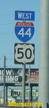
...U.S. Rt. 50, from Sunset Hills to M.P.247, near Union.

...U.S. Rt. 71, at M.P. 18, near Fidelity, to M.P. 11,at Joplin
...Interstate 49, at Joplin.

In December, 2015 into January, 2016, Interstate 44 and 55 were closed to all traffic in each direction near St. Louis. This was dues to flooding of the highway. Many local roads were shut down as well. These are pictures of a variable message board on SB Interstate 57, near Manteno, Illinois.

A VMS on SB I-57, near Manteno, IL. (January, 2016)

A VMS on SB I-57, near Manteno, IL. (January, 2016)

A VMS on SB I-57, near Manteno, IL. (January, 2016)

Interstates that I-44 cross in Missouri...

Interstate 49, near Joplin.
Interstate 270, at Sunset Hills.

The frist BGS on EB I-44/U.S. Rt. 50.

Another BGS on EB I-44/U.S. Rt. 50.

A BGS on EB I-44/U.S. Rt. 50.

EB I-44/U.S. Rt. 50 one mile from I-270.

EB I-44/U.S. Rt. 50 near I-270.

EB I-44/U.S. Rt. 50 at I-270.

A BGS two miles from I-270 on EB I-44/U.S. Rt. 50. (June, 2022)

EB I-44/U.S. Rt. 50 one mile from I-270. (June, 2022)

EB I-44/U.S. Rt. 50 near I-270. (June, 2022)

EB I-44/U.S. Rt. 50 before I-270. (June, 2022)

EB I-44/U.S. Rt. 50 at I-270. (June, 2022)

WB I-44 two miles from I-270.

A BGS on WB I-44 near I-270.

WB I-44 near I-270.

WB I-44 at I-270.

A set of lane markers on the ramp from WB I-44 to I-270.

The ramp from WB I-44 at the split for both directions of I-270.

WB I-44 under two miles from I-270. (June, 2022)

WB I-44 about one mile from I-270. (June, 2022)

WB I-44/U.S. Rt. 50 near I-270. (June, 2022)

WB I-44/U.S. Rt. 50 at I-270. (June, 2022)
Interstate 55, at St. Louis.

The first BGS for I-55 on EB I-44.

EB I-44 near I-55.

EB I-44 at I-55.

EB I-44 over one mile from south I-55. (July, 2014)

EB I-44 near SB I-55. (July, 2014)

EB I-44 at SB I-55. (July, 2014)

EB I-44 one and a half mile from south I-55. (May, 2022)

EB I-44 one and a quarter mile from south I-55. (May, 2022)

EB I-44 a half mile from south I-55. (May, 2022)

EB I-44 at south I-55. (May, 2022)

WB I-44 under one mile from SB I-55. (June, 2019)

WB I-44 near SB I-55. (June, 2019)

WB I-44 at SB I-55. (June, 2019)

SB I-55 near WB I-44. (June, 2022)

SB I-55 before WB I-44. (June, 2022)

SB I-55 at WB I-44. (June, 2022)
Interstate 55, at St. Louis.
Interstate 64, at St. Louis.

Lane markers prior to the interchange with I-55/64. (July, 2014)

EB I-44 near I-55/64. (July, 2014)

EB I-44 at I-55/64. (July, 2014).
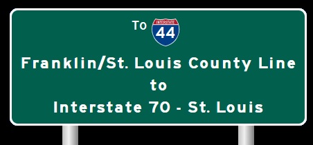
Interstate 70, at St. Louis.
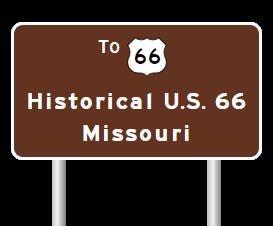
Branches of I-44 in Missouri.


Info on the former highway along the I-44 alignment in Missouri.

U.S.66 in Missouri.


A BGS on BUSN U.S. Rt. 71; MO St Rt 96/171/571 near Carthage.

WB I-44 near M.P. 225

This picture and the one below at of a bridge and grade incline near Rolla. EB I-44 near Rolla.

WB I-44 coming through the same bridge and grade incline.

WB I-44 west of Rolla

EB I-44 near Rolla

A BGS on BUSN Loop I-44/MO St Rt 72.

A BGS on BUSN Loop I-44/MO St Rt 72.

A guide marker on BUSN Loop I-44/MO St Rt 72.

A BGS on BUSN Loop I-44/MO St Rt 72.

WB I-44 at MO Sec St Rt E in Rolla.

EB I-44 at Rolla.

WB I-44 east of MO Sec St Rt E in Rolla.

WB I-44 at BUSN Loop I-44/U.S. Rt. 63.

A junction marker on EB BUSN Loop I-44/NB U.S. Rt. 63.

A guide marker on EB BUSN Loop I-44/NB U.S. Rt. 63.

A guide marker on EB BUSN Loop I-44/NB U.S. Rt. 63.

A BGS on SB U.S. Rt. 63.

A guide marker on SB U.S. Rt. 63.

A guide marker on SB U.S. Rt. 63.

WB I-44 east of BUSN Loop I-44/U.S. Rt. 63.

EB I-44 east of BUSN Loop I-44/U.S. Rt. 63.

EB I-44 east of Rolla.

EB I-44 west of MO Sec St Rt V in Phelps County.

WB I-44 west of MO Sec St Rt V in Phelps County.

WB I-44 at MO Sec St Rt V in Phelps County.

A guide marker on NB MO Sec St Rt V.

EB I-44 east of MO Sec St Rt V in Phelps County.

EB I-44 west of St. James.

WB I-44 west of St. James.

EB I-44 west of St. James.

A guide marker on WB MO St Rt 68.

A guide marker on WB MO St Rt 68.

A BGS on WB MO St Rt 68.

EB I-44 at St. James.

EB I-44 east of St. James.

EB I-44 at the Crawford/Phelps County Line.

EB I-44 east of MO Sec St Rt F/ZZ.

EB I-44 west of MO St Rt 19.

A guide marker on SB MO St Rt 19.

A guide marker on NB MO St Rt 19.

EB I-44 east of MO Sec St Rt H.

EB I-44 west of Bourbon.

A guide marker in Bourbon.

A guide marker in Bourbon.

EB I-44 neat St. Cloud.

EB I-44 at the Crawford/Franklin County Line.

A guide marker in Sullivan.

A BGS and guide marker in Sullivan.

EB I-44 west of south MO St Rt 185/MO Sec St Rt AF at Oak Grove Village.

EB I-44 at south MO St Rt 185/MO Sec St Rt AF at Oak Grove Village.

EB I-44 east of south MO St Rt 185/MO Sec St Rt AF at Oak Grove Village.

EB I-44 east of Sullivan.

EB I-44 at MO Sec St Rt W/JJ.

EB I-44 east of MO Sec St Rt W/JJ.

EB I-44 west of St. Clair.

EB I-44 west of MO St Rt 30.

WB I-44/U.S. Rt. 50 near Villa Ridge.

A junction marker on WB MO St Rt 100.

A BGS on WB MO St Rt 100.

WB I-44/U.S. Rt. 50 near M.P. 257.

EB I-44/U.S. Rt. 50 near Gray Summit.

EB I-44/U.S. Rt. 50 at the Franklin/St. Louis County Line.

EB I-44/U.S. Rt. 50 at the Franklin/St. Louis County Line.

WB I-44/U.S. Rt. 50 at the Franklin/St. Louis County Line.

WB I-44/U.S. Rt. 50 west of Six Flags-St. Louis.

A set of guide markers on BUSN Loop I-44.

WB I-44/U.S. Rt. 50 near Six Flags-St. Louis.

WB I-44/U.S. Rt. 50 west of MO St Rt 109.

WB I-44/U.S. Rt. 50 east of the Meramec River.

WB I-44/U.S. Rt. 50 near Forest 44.

WB I-44/U.S. Rt. 50 near M.P. 268.

EB I-44/U.S. Rt. 50 east of M.P. 269.

WB I-44/U.S. Rt. 50 west of MO St Rt 141.

A BGS on SB MO St Rt 141.

A BGS on SB MO St Rt 141.

EB I-44/U.S. Rt. 50 east of MO St Rt 141.

EB I-44/U.S. Rt. 50 east of MO St Rt 141.

A guide marker in Fenton.

A BGS on SB I-270.

WB I-44/U.S. Rt. 50 at the stack with I-270.

A BGS on the ramps from I-270to EB I-44.

EB I-44/U.S. Rt. 50 west of Lindberg Blvd.

EB I-44/U.S. Rt. 50 west of Lindberg Blvd.

A BGS on EB I-44/U.S. Rt. 50.

EB I-44 east of Lindberg Blvd.

EB I-44 in Crestwood.

EB I-44 at Big Bend Road.

EB I-44 east of Big Bend Road.

EB I-44 at Elm Ave.

EB I-44 east of Elm Ave.

EB I-44 east of Elm Ave.

EB I-44 near Laclede Station Road.

EB I-44 west of the River Des Peres.

WB I-44 at the St. Louis County/City of St. Louis line.

EB I-44 at the St. Louis County/City of St. Louis line.

EB I-44 west of Jamieson Ave.

A guide marker in Webster Grove.

EB I-44 near Southwest Avenue.

EB I-44 near Hampton.

EB I-44 at Hampton.

EB I-44 at Macklind Avenue.

EB I-44 at Kingshighway.

WB I-44 near Vaderventer.

EB I-44 east of Vanderventer.

EB I-44 at Thruman.

EB I-44 near Grand.

EB I-44 at Compton.

EB I-44 at Compton.

WB I-44 at Nebraska.

A BGS on NB I-55.

A on WB I-44.

EB I-44/NB I-55 at Park Ave. in St. Louis.

EB I-44 at the Poplar Street.

WB I-44 at Poplar Street.

EB I-44 at Spruce.

A BGS on SB I-55.

A BGS on the ramp from SB I-55 to EB I-44.

EB I-44 near Walnut.

EB I-44 at Walnut.

EB I-44 at Pine.

A guide marker on 4th in St. Louis.

A guide marker on 4th in St. Louis.

A guide marker on 4th in St. Louis.

A BGS on Market in St. Louis.

A guide marker on 8th in St. Louis.

A guide marker on NB 4th Street in Downtown St. Louis.

A guide marker on Washington in St. Louis.

A BGS on Washington in St. Louis.

A guide marker on Washington in St. Louis.

A guide marker on Washington in St. Louis.

A BGS on Washington in St. Louis.

EB I-44 at Washington.

A set of guide markers on Washington in Downtown St. Louis.

A set of guide markers near the Dome in Downtown St. Louis.

A guide marker north of Downtown St. Louis.

WB I-44 at Cole Street.

EB I-44 near the Edward Jones Dome.

EB I-44 near the start of the express lanes.

EB I-44 near Broadway.

WB I-44 at Broadway.

WB I-44 at I-70 in north St. Louis.

A BGS on EB I-70.

The eastern end point. (July, 2014)

The eastern end marker. (July, 2014)

The first end marker one mile from the east end of I-44. (May, 2022)

The east end of I-44. (May, 2022)

The former end point.
Prior to 2014

The end marker for EB I-44. (Feb., 2005)

The end marker on EB I-44. (June, 2006)

1 July 2023