
Bolingbrook to Gardner
U.S. 66, via Plainfield, Braidwood, Braceville, & Gardner
As traffic volumes on U.S. 66 grew, the highway was bypasses to the west side of the Joliet Area. the original sections was changed to U.S. 66A or ALT U.S. 66. The two alignments split at the Joliet Road exit on Interstate 55. This is part of the interchange with Interstate 55 and Interstate 355. This alignment follows I-55 south to Exit 261/Illinois 126. U.S. 66 follows IL 126 west to U.S. 30/IL 59. At this intersection the road turns south (right) and heads south on IL 59. The section of IL 59 from IL 129 to East U.S. 30 is a dual-alignment with the Lincoln Highway. At Shorewood, U.S. 66 re-joins I-55 south. It followed I-55 south to Exit 238/IL 129. This exit has since been closed. You can exit at Exit 240/Lorenzo Road and use the east Frontage Road to join IL 129 at the interchange. As U.S. 66/IL 129 comes out of a long curve the Union Pacific Railroad (ex-Illinois Central Gulf, Gulf Mobile & Ohio, Chicago & Alton) tracks and ALT U.S. 66 come into view. Once in Braidwood, at IL 113, IL 129 ends. U.S. 66 continues straight on an unmarked state highway. At Braceville you will come to a four-way stop. This highway continued on from here to cross the Pequot Subdivision of the Union Pacific Railroad. The bridge over this railroad has since been removed. Thru traffic needs to use ALT. U.S. 66. You can turn left and cross the railroad tracks at the four-way stop in Braceville. Then next railroad crossing is at Carbon Hill Road in Gardner. Just north of the crossing is another four-way stop. This is where you rejoin the alignment of U.S. 66 you were traveling on. To the right you can travel back one mile to where the southern approach was to the railroad overpass. If you turn left U.S. 66 forms a northern bypass around Gardner. Prior to the bridge north of town over the Mazon River and Union Pacific was removed, this was signed as IL 129. Local street signs still indicate this highway as IL 129. On the west side of Gardner you will come to a four-way stop. This was the end point of IL 129, and is the end point of IL 53. To the west of this four-way stop is the Gardner interchange with I-55. Just south of the four-way stop is a Frontage Road entrance across from the Gardner American Legion. This is where the two Bolingbrook to Gardner sections join back up.
View U.S. 66 Will County, IL in a larger map
Bolingbrook
Through Bolingbrook, U.S. 66 passes completely on Interstate 55.

A tourist monument at the Pomenade in Bolingbrook.
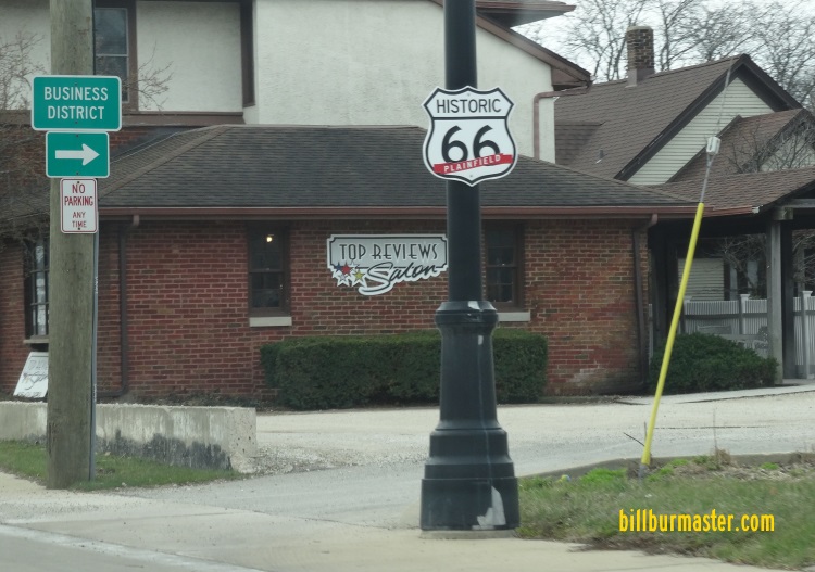
Plainfield
At Plainfield, U.S. 66 went in to the town (via Current IL 126) and turned south and passed the eastern edge of Downtown (via IL 59).

A marker on U.S. Rt. 30/IL St Rt 59.
A marker on U.S. Rt. 30/IL St Rt 59.
Joliet
In the days of Rt 66, Joliet never came this far west. Due to urban sprawl, the city now extends past this route into Kendall County to the west.
Shorewood
This is a small town being swept up in the rapid development of urban life. Most of the businesses are to the west on U.S. Rt. 52. On the south end of Shorewood IL 59 ends and traffice is filtered back on to I-55.
Shorewood
Not much here. Joliet wraps around this town. To the south of Preston Heights is the Chicagoland Speedway and Route 66 Raceway.

Looking NB on U.S. 66 in Preston Heights.
Channahon
At Exit 248/U.S. 6 on Interstate 55 you will find the Manor Motel. This is a classic 66 era motor lodge.

The sign for the motel.

Looking at the Manor Motel.
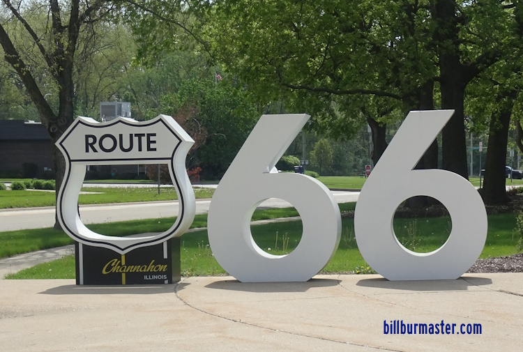
A tourist monument in Channahon.
Rural Will County
As you head down this alignment of U.S. 66 (now I-55), you pass I-80. Before this interchange was repaired a few years back, you use to be able to see the imprint of the 66 shield on the BGS on I-80, behind the current I-55 shields. Those signs have since been replaced.
Further down, U.S. 66 crosses the Des Plaines river in great, gray bridges.

Looking north at the gray bridges on ALT. Rt. 66 (I-55) south of Joliet.
Northwest of Wilmington, U.S. Rt. 66 leaves I-55 and heads on original road (IL 129). As noted above the IL 129 exit has been removed. You need to use Exit 240 and take the east frontage road to join IL 129.
Braidwood
Just north of Braidwood is a old advertisement. It is located on at the intersection with Coal City Road and Rt. 66 (now IL 129). At the corner it is located on the northwest side. To see this you will nee to park you car and look head. The winter months, when there is no leaves on the trees, is the best time to view it. the ad was for a local place called "Faletti's Orchestra". The placed a grand piano on the top of the hill. It is said that a sign for the business was at one time located at the base of the hill. That is long gone, but the piano is still there. The piano is said to date back to the late 40's early 50's. Not much of it remains. The below photos were taken in February of 2006.

Looking up at the piano from the corner of Coal City Road and Rt. 66. the circle indicated where the piano is.

Looking at what is left at the grand piano.

Looking back down at the corner of Coal City Road and Rt. 66 from the piano. The semi-truck is on SB Rt. 66 (IL 129).

The Braidwood Motel along Rt. 66 (IL 129).
At Braidwood, this is the first place you can see the original alignment of U.S. 66. The two alignments run along each side of the Union Pacific tracks to Gardner. Also at Braidwood, this route parallels a later alignment of U.S. 66. Braidwood is home to the Fossil Ridge Public Library. This is located off of John F. Kennedy Road, west of both U.S. 66 alignments. On display here are artifacts and fossils from the area. Along IL 113 west of U.S. 66 is the Braidwood Historical Museum. The museum is located in the former Chicago & Alton train depot. This depot sat along the Union Pacific Railroad (ex- Chicago & Alton) on IL 113 between both alignments of U.S. 66. It was moved during a reconstruction project, and is now located along IL 113 near the City Hall and Police Department.
Godley
Godley is a small village at the Will/Grundy County Line. It sits on the south side of the highway, just west of the Exelon Nuclear Generating Station. Godley is home to the Kmine museum. This shows sights of the fossils from the area. On the south end of Godley on Kankakee Street, the county line, is the Godley Park District. This place has playground equipment and trails to walk on. It also give access to the Braidwood-Mazonia Fish and Wildlife Area.
Braceville
Braceville is a small town along U.S. 66. This is located just west off the Grundy/Will County Line. As of now this is where the road comes to a end. Just south of the town, was the bridge over the UPRR Spur to Coal City. Due to lack of funding and years of despair, the bridge was closed then tore down. You can still go to the old bridge site (on both sides). The embankments are still there and concrete and guide cables are a mess in the weeds.

A sign in Braceville.

NB U.S. 66 (ALT.) near old bridge.

This is the end of the pavement these days on the Gardner side. IDOT recently repaved this section of the road, and created a turn around here.

The UPRR over the Mazon River, next to where ALT U.S. 66 ran.

A guide cable and concrete from the old bridge, among the over growth.

Looking back south from the old bridge area.

Looking at the bridge from the southside at the Mazon River near gardner. Photo Courtesy Rich Carlson "Illinois Highway Page"
Gardner
This alignment of U.S. 66 forms the northern ring around the town. IL 129 use to end at the intersection on IL 53 (also where that ends) on the westside of town near the interchange with I-55. One of the mian attractions of Gardner is a park that has the towns old two-cell jail, and a street car from the Riviara Resturant that was once north of town. This is located near downtown.
66 near Carbon Hill Road at Gardner.
Street sign at Old Rt. 66 and Carbon Hill Road still labels the intersection as IL 129.
A mural in Downtown Gardner.
The jail.
Looking at the park with the jail and street car.
A marker for the jail.
A marker for the street car.
The street car.
A tourist monument in Gardner. (September, 2024)
Bolingbrook-GardnerBolingbrook-Gardner/ALT U.S. 66Interstate 55U.S. 30Illinois 53Illinois 59Illinois 129


