Springfield to Staunton
via Chatham, Virden, Carlinville, & Staunton
The first alignment of U.S. 66 followed what is now Illinois 4. This splits from a later alignment of U.S. 66 on the northside of Springfield, near the Illinois State Fairgrounds. It passes through the heart of Springfield before heading south along towns that were forgotten by Interstate 55.
View Springfield to Staunton 1926-1930 in a larger map
Springfield
The first point of interest along U.S. 66 is the Illinois State Fairgrounds, on the north side of the city.

The sign at the IL St Fairgrounds.

An Abraham Lincoln statue on the Illinois State Fairgrounds.

A look at thr Route 66 Experience on the Illinois State Fairgrounds.

A set of grandstands on the fairgrounds.

SB U.S. 66 near the IL St Fairgrounds Gate 7.

A changeable BGS on SB U.S. 66 at the IL St Fairgrounds.

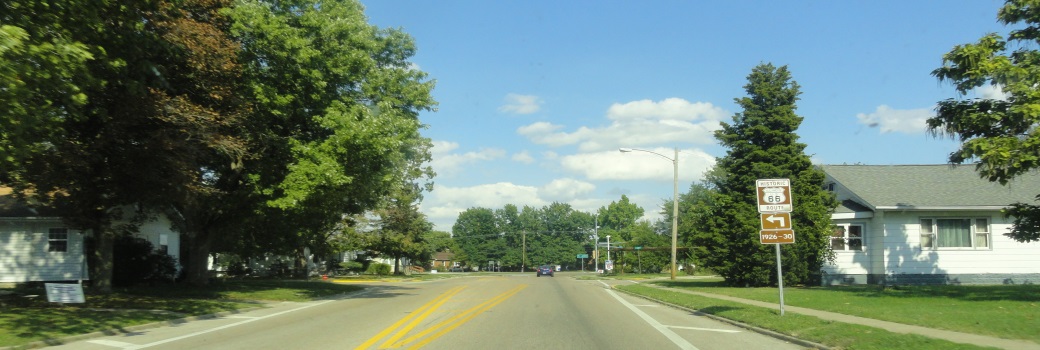
This is near the northern end of the 1926-1930 alignment of Rt. 66.

Shea's Station in Springfield, south of the state fairgrounds. (July, 2024)

A plaque at Shea's. (July, 2024)
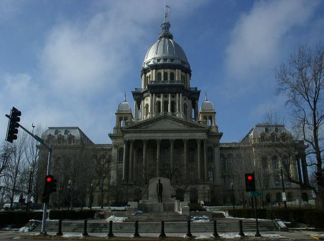
The Illinois State Capital.
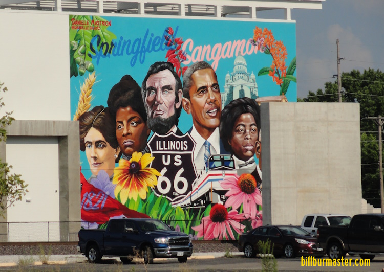
A mural on the new transportation center in Downtown Springfield. (July, 2024)

A mural on the side of the fire department.

Just Off Route66 Sandwiches & Souvenirs on Cook Street in Springfield.

A close-up of a marker at Just Off Route66 Sandwiches & Souvenirs on Cook Street in Springfield.


A mural in Springfield.

A mural in Springfield.

A mural in Springfield.

A mural in Springfield.

SB U.S. 66 on South Grand Ave, east of Mac Arthur Blvd.
U.S. 66 turns west and follows Wabash from Mac Arthur to Old Chatham Road, then heads south.

Muffler Man on Wabash Ave.
Chatham
U.S. 66 follows Old Chatham Road to Woodside Road. Then heads south along Illinois 4.

A mural along Rte. 66 in Chatham.

A mural in Chatham.
Rural Sangamon County
Just north of a small town called "Thayer" that IL St Rt 4 by-passes, U.S. 66 splits off from IL 4. Actually when the road was up-graded to current standards IDOT straighten the road to a "S" Curve from two sharp curves. The original section is still cobble stone. and striped.

Looking south on the stone section

Looking northeast as the road turns from north-south to east-west.

Looking east.

Looking at the deck. Notice the new coble stone...

A side view of the bridge.

Auburn
U.S. 66 runs along the western edge of Auburn, bypassing the town.

NB Rt. 66 in Auburn.

Virden
Another nice town. They do have a town square. Not quite as nice as Carlinville...but aged...

A mural north of the square.

A road side marker for the coal industry in the area in the townsquare in Virden.

A close-up of the marker above.

A mural in Virden.
Girard
The only this memorable about this area is the amount of railroads. Tracks from the Union Pacific, Norfolk Southern, and BNSF Railways all intersect here.

A mural in Girard.
Nilwood
This is a little town that time has not been kind to. Besides a bar and the United States Post Office, there is not much to this town. Illinois 4 by-passes the town. U.S. actually went through the town and on the east side turned north then went northeast on the side of town.

A older Railroad underpass north of Nilwood. This dates back to 1930 (Click on Pictures for date in pier). This view is looking west. The bridge either belongs to the Union Pacific or Norflok Southern Railroad.
Same railroad bridge looking east.

Looking west as U.S. Rt. 66 curves south towards Nilwood. Notice how warn the road is from years of service.
Carlinville
This is the biggest of the towns that you come across so far on the 1926-30 segment. This is home to Blackburn College. Plus, its the home to the Macoupin County Courthouse.

Illinois 4 is multi-plexed with Illinois 108 through town.

The Macoupin County Courthouse. Worth stopping for a picture.

On the grounds of the courthouse is the Macoupin County Veterans Memorial.
After you go past the courthouse Illinois 4 & Illinois 108 turn and come to a very nice town square. This is also where they go their separate ways.

This is what you see when you approach the square.

The square in Downtown Carlinville and the Macoupin County Courthouse in the background.

Signage on a pole in the square.

A mural in Carlinville.

A mural in Carlinville.

A marker on the town square in Carlinville.

A close-up of the marker above in Carlinville.

A marker at the old jail in Carlinville.

A marker at the old jail in Carlinville.
Rural Macoupin County
As you journey up Il St Rt 4 you'll find U.S. 66 turns to a side road for it's route.

This is a worn, narrow, two-lane concrete road.

This is about a 1/4 north of the above picture. The current IL St Rt 4 is to the right on the hill.

An orignal bridge from the days that U.S. 66 went through these parts.

The plaque from the bridge above. Dating the bridge back to 1920.
Gillespie
This is the next major town. This is the second place Illinois 4 multi-plexes on this segment.


A few signs in town.

NB U.S. 66 in Gillespie.

The Illinois Coal Museum.

A mural in Gillespie.
Benld
Again Illinois 4 is multi-plexed, this time with Illinois 138.

The old Coliseum Ballroom at Benld.
Staunton
U.S. 66 weaves its way through the middle of Staunton. South of town it rejoins with the 1930-1940 segment and the 1940-1977 segment.
Springfield-StauntonSpringfield-Staunton/1930-1977Illinois 4


